San Antonio faces weekend arctic outbreak with freezing rain risk and dangerous wind chills into Sunday
Arctic air and ice potential could extend cold impacts across South Central Texas
San Antonio is preparing for a sharp turn toward winter conditions as an arctic airmass is expected to arrive Friday evening and persist through the weekend, bringing a risk of icing and potentially dangerous wind chills. Forecast guidance issued Tuesday, Jan. 20, 2026, indicates very high confidence in hazardous cold through the weekend, while the details of any ice accumulation remain less certain.
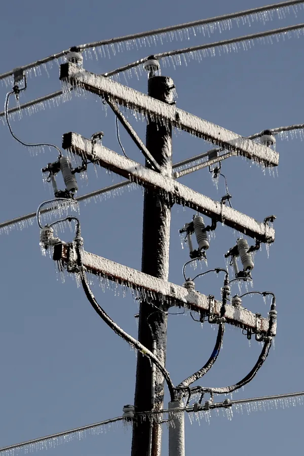
The greatest ice risk is projected for the Hill Country and the Interstate 35 corridor, where probabilities are highest for at least one-tenth of an inch of ice between early Saturday and Sunday. For San Antonio, the probability of reaching that ice threshold is lower, but the metro area remains within the region where wintry precipitation could still affect travel and infrastructure depending on subtle shifts in temperature and precipitation timing.
What “bitter cold” could mean on the ground
Forecast messaging points to a weekend period in which the combination of low temperatures and wind could push wind chill values into the teens in the San Antonio area by Sunday morning, with colder readings possible north and west of the city. Even when measured temperatures remain above the most extreme values, wind-driven heat loss can elevate the risk of cold-related illness for those without adequate shelter, as well as create conditions that can stress plumbing and vulnerable vegetation.
Key uncertainties heading into the weekend include the onset and end time of freezing temperatures and the duration of any icing.
Geography matters: why the Hill Country may see worse impacts
Small differences in elevation and local microclimates frequently lead to colder overnight lows in the Hill Country than in central San Antonio. That matters during marginal winter events, when a one- or two-degree change can determine whether precipitation falls as cold rain or accumulates as ice on bridges, overpasses, and power lines.
Preparedness focus for residents and local operations
With confidence high that the weekend will bring the coldest conditions of the season so far, the focus for households typically centers on preventing freeze damage and reducing exposure risks. Public safety messaging around arctic outbreaks commonly emphasizes readiness before temperatures drop, because response options narrow once roads ice over.
- Check heating systems and ensure safe indoor heating practices.
- Protect exposed pipes and outdoor faucets ahead of the coldest period.
- Limit time outdoors during the coldest wind chill window, especially for children and older adults.
- Prepare for travel disruptions if icing develops, particularly on elevated roadways.
Forecasters expect the risk window for ice to center on early Saturday through Sunday. Residents are advised to monitor updated forecasts as the event approaches, since small changes in storm track and surface temperatures will determine whether San Antonio experiences mainly bitter cold, or a more disruptive mix of cold and ice.